


by David Moran, on Jul 12, 2018 11:07:55 AM
Thunderstorms are forecast to develop across portions of the Northern Plains and Western Great Lakes on Thursday ahead of a cold front. Abundant moisture and daytime heating will allow for the development of thunderstorms across the Carolinas. The potential for excessive rainfall will continue for portions of the Southwest and Southern Rockies through Saturday as an upper level low continues to move through the region.
- Thunderstorms for the Northern Plains and Western Great Lakes on Thursday
- Potential for Thunderstorms Thursday across the Carolinas
- Excessive Rainfall Continuing across the Southwest and Southern Rockies through Saturday
- Risk for Thunderstorms Friday for the Midwest
- Potential for Excessive Rainfall across the Midwest Friday and Saturday
- Tropical Update
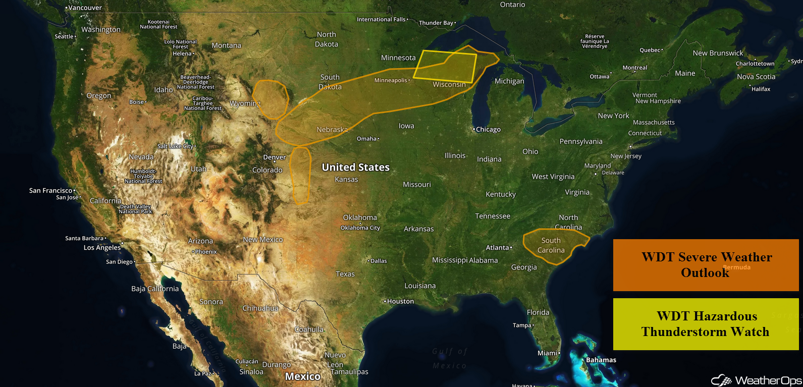
US Hazards
Thunderstorms for the Northern Plains and Western Great Lakes on Thursday
Ongoing thunderstorm activity will continue along a cold front that is forecast to move southeastward and then stall. Additional thunderstorms may develop along the front during the afternoon and evening. Strong winds and large hail will be the primary hazards with these storms. In addition, frequent lightning, heavy rain, flooding, and flash flooding will also be potential hazards.
Major Cities in Region: Sioux Falls, SD, Minneapolis, MN, Wausau, WI, Marquette, MI
Thunderstorm Risk for Thursday
Potential for Thunderstorms Thursday across the Carolinas
Strong instability is forecast to develop as a result of plentiful moisture and daytime heating. As a front moves eastward across the region, strong to severe thunderstorms are expected along and ahead of the front during the afternoon and evening. Strong wind gusts and hail will be the primary hazards with these storms.
Major Cities in Region: Myrtle Beach, SC, Wilmington, NC
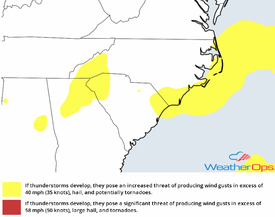
Thunderstorm Risk for Thursday
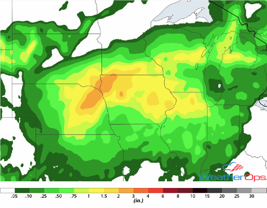
Excessive Rainfall Continuing across the Southwest and Southern Rockies through Saturday
Thunderstorms are expected to continue across the Southwest and Southern Rockies through Saturday as an upper level low remains in place over the region. This will allow for a risk for excessive rainfall through Saturday. Three day rainfall totals of 2-4 inches are expected with locally higher amounts in excess of 5 inches.
Major Cities in Region: Flagstaff, AZ, Phoenix, AZ, Tucson, AZ, Albuquerque, NM
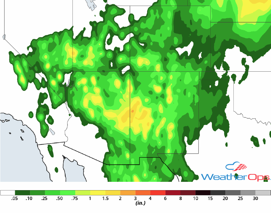
Rainfall Accumulation through Saturday
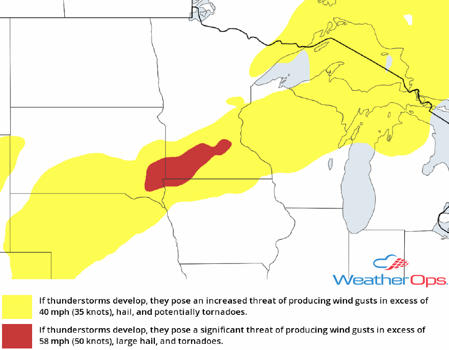
Risk for Thunderstorms Friday for the Midwest
A stalled front is expected to extend across the Midwest on Friday. Strong daytime heating and plentiful moisture will allow moderate instability to develop. With the front providing lift. thunderstorms are expected to develop by the afternoon. Strong winds and large hail will be the primary hazards with these storms.
Major Cities in Region: Omaha, NE, Des Moines, IA, Milwaukee, WI
SPC Convective Outlook for Friday
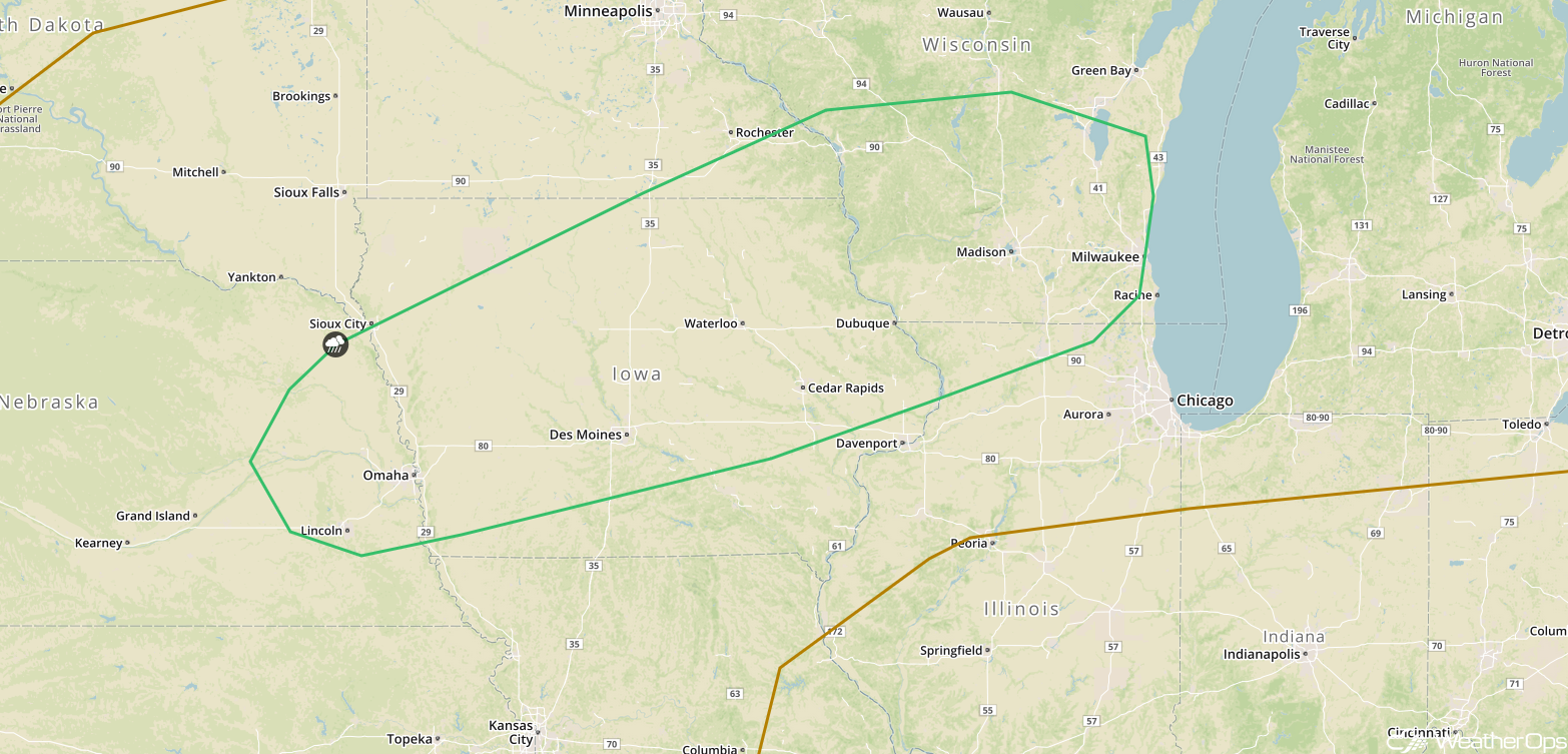
Potential for Excessive Rainfall across the Midwest Friday and Saturday
In addition to the thunderstorm potential described above, there will be a risk for excessive rainfall Friday into Saturday. Two day rainfall amounts will range 1.50-3.00 inches with locally higher amounts.
Major Cities in Region: Sioux Falls, SD, Sioux City, IA, Cedar Rapids, IA
Rainfall Accumulation for Friday and Saturday
Tropical Update
Post-Tropical Cyclone Chris (green oval) is located 290 miles east of Halifax, Nova Scotia and is moving northeastward at 36 mph. This motion is expected to continue through Friday with Chris passing over or near southeastern Newfoundland late this afternoon and early evening. Maximum sustained winds are at 70 mph. Additional weakening is expected over the next 48 hours.
An area of disorganized showers and thunderstorms associated with the remnants of Beryl (red oval)l is located between the Bahamas and Bermuda. Little to no development is expected through Friday while the system moves northeastward. However, environmental conditions could become a little more favorable over the weekend as the system moves northward over the warm waters of the western Atlantic.
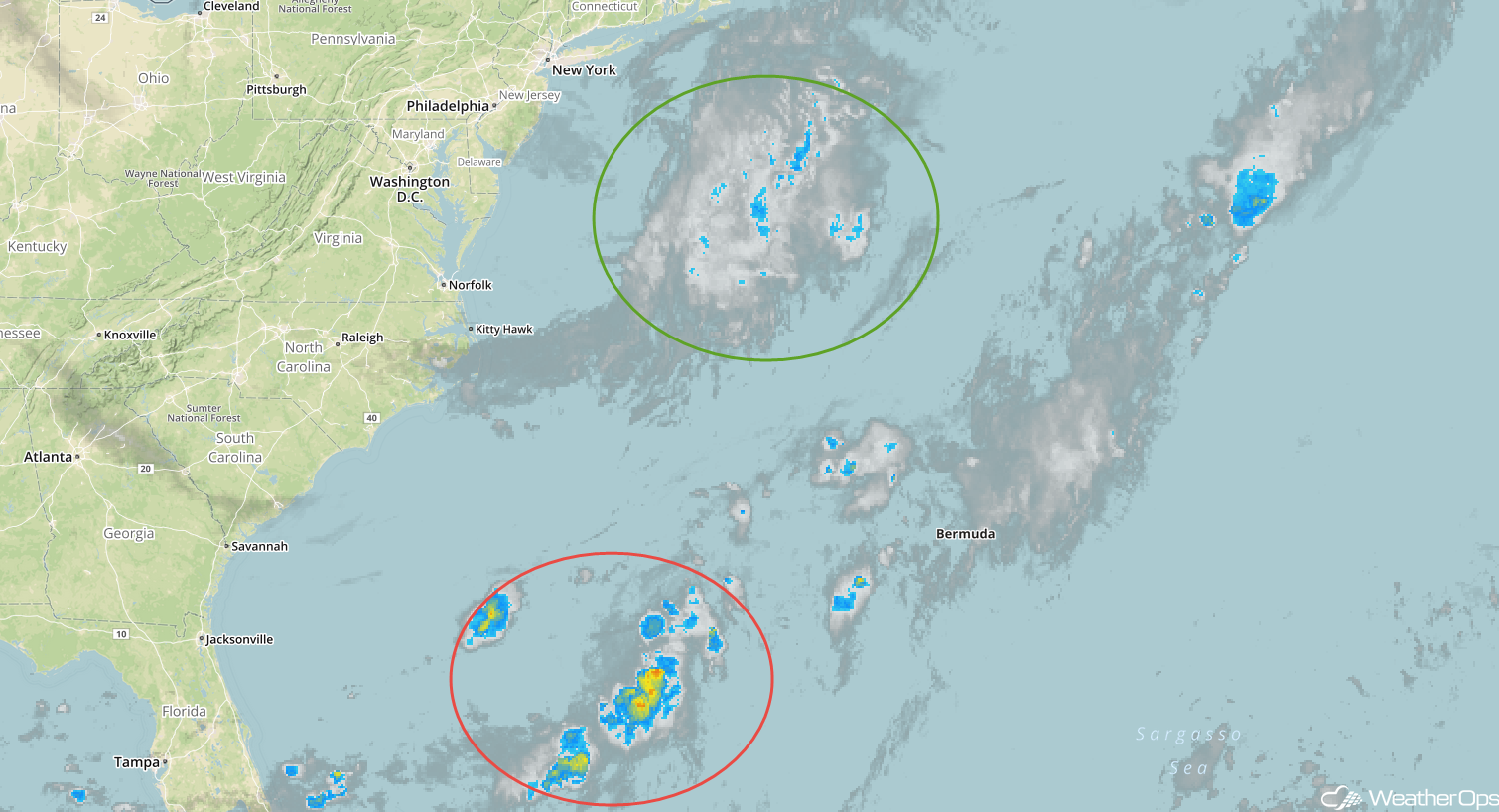
Enhanced Infrared Satellite
A Look Ahead
A cold front moving across the Northern Plains and Upper Midwest will be the focus for the development of thunderstorms on Sunday. As the cold front continues to move southeastward on Monday, showers and thunderstorms will extend from the Great Lakes into the Central Plains. On Tuesday, showers and thunderstorms are forecast from the Southeast through the Ohio Valley and into the Northeast. Another round of showers and thunderstorms may develop across portions of the Plains on Wednesday.
