


by David Moran, on Jul 27, 2018 10:55:56 AM
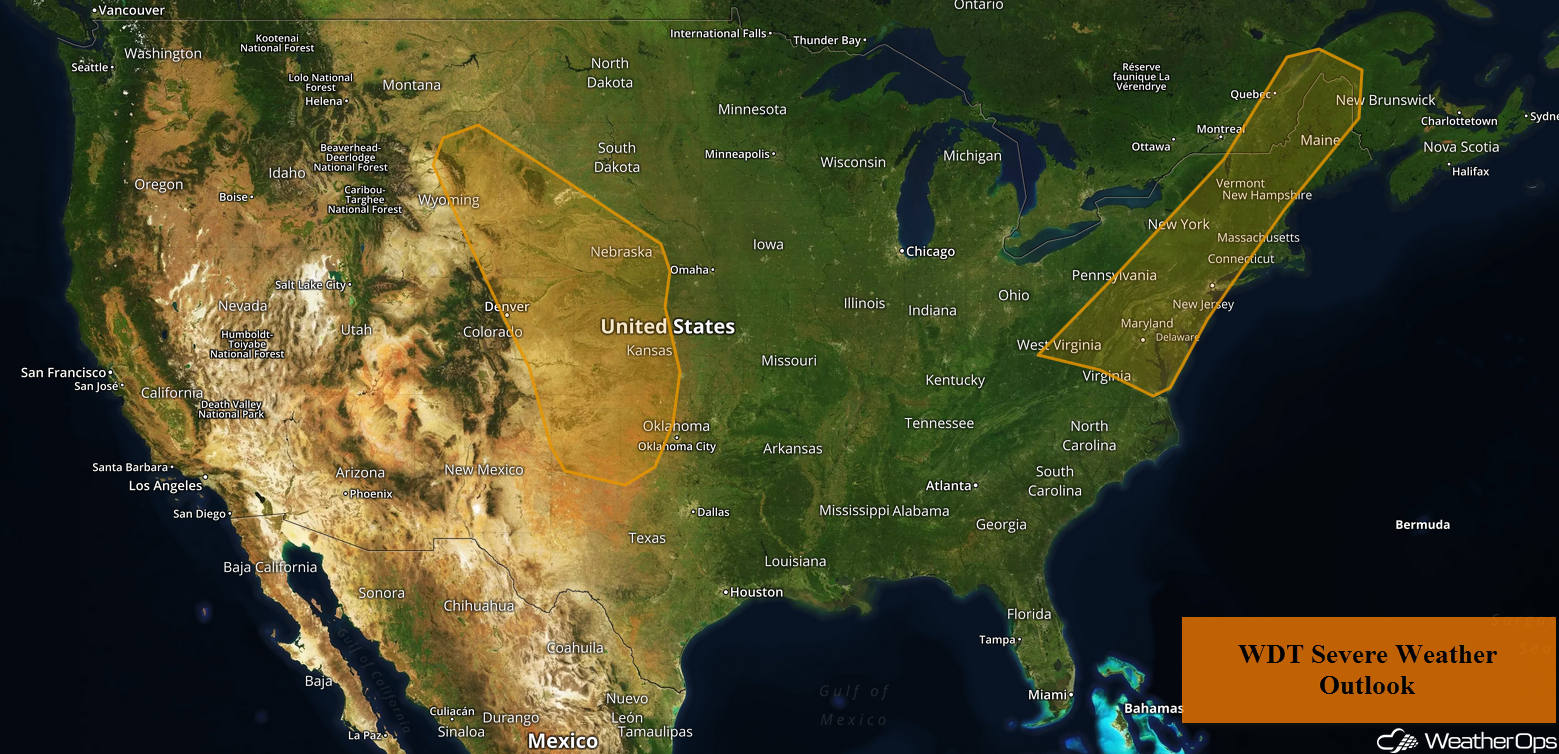
Thunderstorms are forecast to develop across the Central Plains on Friday as an upper level disturbance moves across the region. These storms will have a potential to produce heavy to excessive rainfall; the risk for excessive rainfall will continue through the weekend. A cold front will be the focus for the development of thunderstorms across the Mid Atlantic and New England. Some of these storms will pose a risk for excessive rainfall.
- Thunderstorms for the Central Plains on Friday
- Excessive Rainfall through Sunday for the Central and Southern Plains
- Potential for Thunderstorms across the Mid Atlantic and New England Friday
- Risk for Excessive Rainfall Friday from the Delmarva Peninsula into Lower New England
- Thunderstorm Potential for the Central Plains on Saturday
- Thunderstorms Saturday for New England
- Risk for Thunderstorms from the Central High Plains into Oklahoma on Sunday
US Hazards
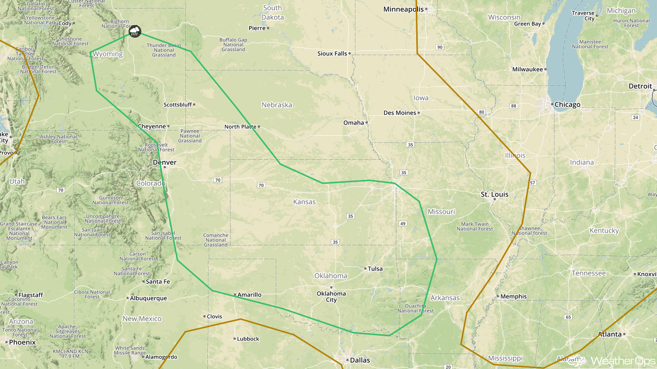
Thunderstorms for the Central Plains on Friday
A shortwave disturbance is forecast to dig across the Central Plains this afternoon as daytime heating increases. With instability building as a result of daytime heating and wind shear increasing, thunderstorms should become severe with damaging winds and large hail the primary hazards. An isolated tornado or two cannot be ruled out.
Major Cities in Region: Scottsbluff, NE, Amarillo, TX, Goodland, KS, North Platte, NE, Dodge City, KS
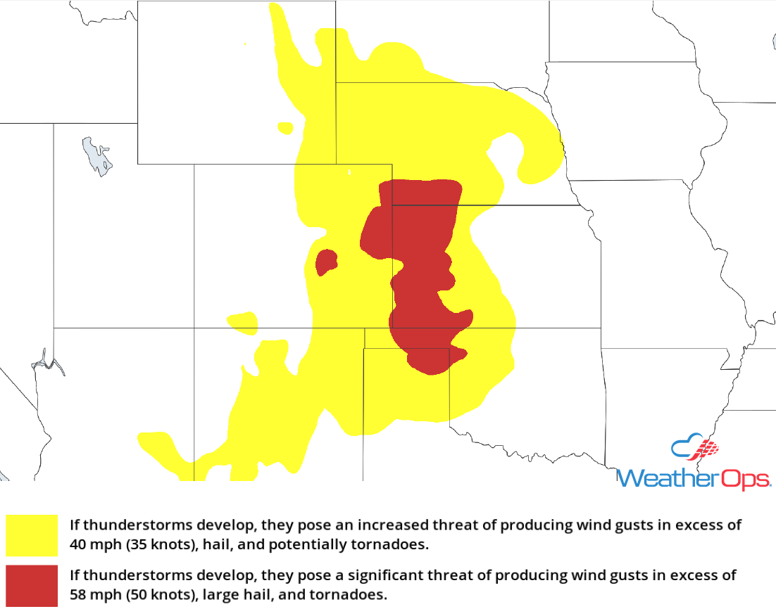
Thunderstorm Risk for Friday
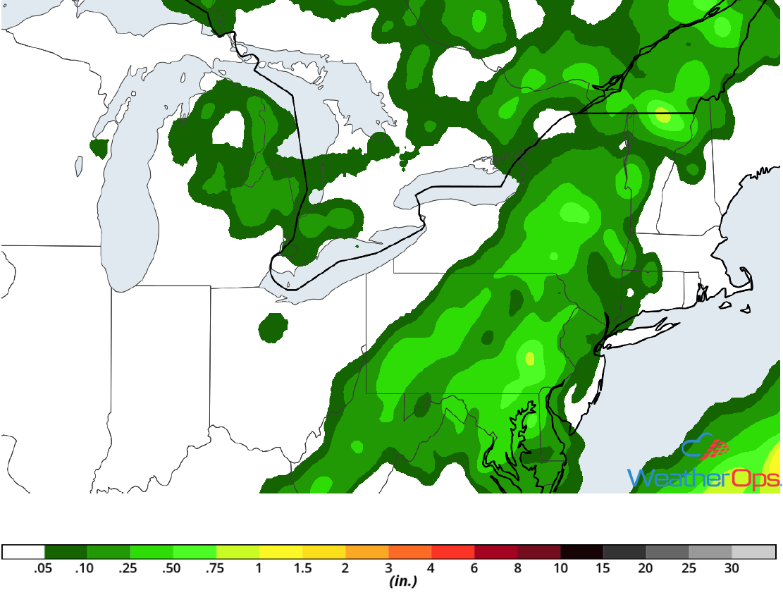
Excessive Rainfall through Sunday for the Central and Southern Plains
A threat for excessive rainfall will continue through the weekend across the Central and Southern Plains as several rounds of showers and thunderstorm activity move across the region. With northwesterly flow aloft, multiple upper level disturbances will move across the region, each posing a risk for shower and thunderstorm activity. Areas that have multiple rounds of thunderstorms may receive 1-2 inches of rain with locally higher amounts. This will contribute to a risk for localized flooding and runoff.
Major Cities in Region: Goodland, KS, North Platte, NE, Dodge City, KS, Wichita, KS
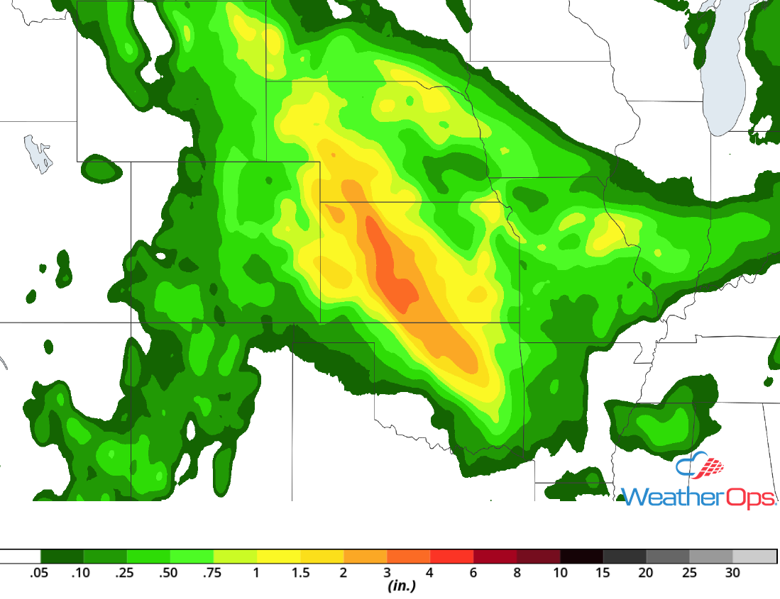
Rainfall Accumulation through Sunday
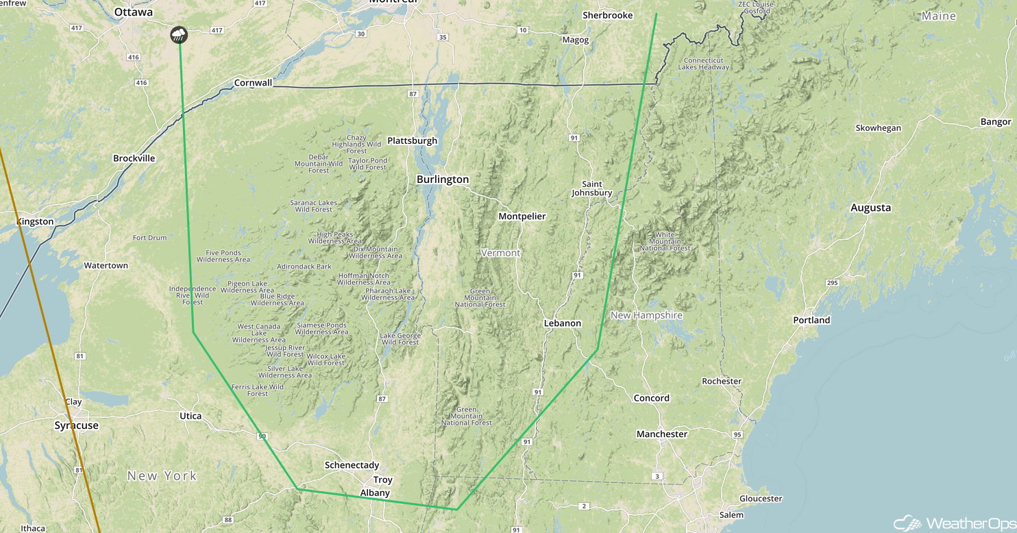
Potential for Thunderstorms across the Mid Atlantic and New England Friday
A cold front will move into the Northeast on Friday. Scattered showers and thunderstorms will likely be ongoing along the front during the morning hours. As the day progresses, building instability should allow some storms to become severe as they track across portions of New England and the Mid Atlantic region. Severe winds will be the primary impact, but some hail cannot be ruled out.
Major Cities in Region: Washington, DC, Baltimore, MD, Philadelphia, PA, New York, NY, Albany, NY, Burlington, VT, Augusta, ME
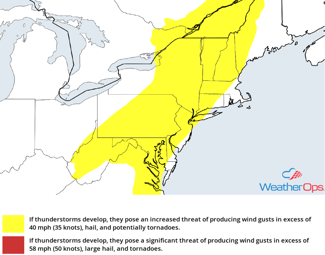
Thunderstorm Risk for Friday
Risk for Excessive Rainfall Friday from the Delmarva Peninsula into Lower New England
Increasing shower and thunderstorm activity is expected with the approach of a cold front. Some activity will have the potential to produce locally heavy rainfall, especially across the Delmarva region. Rainfall totals in excess of an inch are expected through early Saturday morning, contributing to a risk for minor flooding and runoff.
Major Cities in Region: Washington, DC, Baltimore, MD, Philadelphia, PA, New York, NY, Providence, RI
Rainfall Accumulation for Friday
Thunderstorm Potential for the Central Plains on Saturday
An area of low pressure will begin to develop on Saturday over the Central Plains, leading to the development of Isolated to scattered showers and thunderstorms. While significant severe weather is not anticipated, a few storms could become marginally severe before dark with gusty winds and hail the primary hazards. A few storms could continue after dark.
Major Cities in Region: Cheyenne, WY, Scottsbluff, NE, Goodland, KS, Amarillo, TX, Dodge City, KS, Oklahoma City, OK, Wichita, KS, Tulsa, OK, Kansas City, MO
SPC Convective Outlook for Saturday
Thunderstorms Saturday for New England
Thunderstorms may develop across portions of New England on Saturday as an area of low pressure moves eastward. Severe winds and hail will be the primary hazards with these storms.
Major Cities in Region: Albany, NY, Burlington, VT
SPC Convective Outlook for Saturday
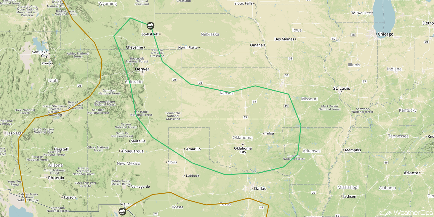
Risk for Thunderstorms from the Central High Plains into Oklahoma on Sunday
Another round of showers and thunderstorm activity is expected across the Plains on Sunday as two disturbances emerge from the Rockies. The first disturbance is forecast to lift across Kansas into Missouri during the morning hours, allowing for a risk of severe thunderstorms capable of producing severe winds. By late evening and after dark, a second disturbance is forecast to move into the Southern Pains. Thunderstorms, some severe, may develop overnight across the Oklahoma and Texas Panhandles into the Red River region with damaging winds and hail the primary hazards.
Major Cities in Region: Cheyenne, WY, Denver, CO, Goodland, KS, Dodge City, KS, Wichita, KS, Oklahoma City, OK, Tulsa, OK, Joplin, MO, Fort Smith, AR
SPC Convective Outlook for Sunday
A Look Ahead
Heavy rain will continue across portions of the Plains on Monday along a stalled front. By Tuesday, an area of low pressure will develop across the Mid Mississippi Valley, bringing a risk for showers and thunderstorms to the Ohio Valley and Southeast. This activity will move eastward into the Appalachians and across the Southeast on Wednesday. Showers will span much of the East Coast on Thursday.
